
Yakama Nation History
Yakama Nation History
Yakama Nation history
FIRST CHIEF OF THE YAKAMA NATION 1856-1861
Chief Spencer’s tribal name was “Tah pa shah”, interpreted to Sharp Shooter. He was Chief of the Klickitats and appointed at the original Yakama Agency in White Swan, Washington. He was confirmed by J.W. Nesmith, Superintendent of Indian Affairs for the Washington-Oregon Territory in 1856.
He was also appointed by U.S. officials since Chief Kamiakin refused to come onto the reservation. Chief Spencer was paid $500 per year and at the end of his appointment was given an officer’s sword.
History of the yakama nation’s Land
Upon central Washington’s plateau and along the Columbia River reside tribal people called the Yakama’s. The Cascade mountains shelter this central portion from marine showers. The rolling foothills and Yakima River are the eastern border.
Due west in majestic glory is Pahto, 12,307 feet high. It is one of five Cascade volcanoes that dot the landscape from California to Washington. Her snow melts through canyons, forests, meadows and valleys to provide gifts to our people.
The tribal people comprising the Yakama Nation have lived in this area since the beginning of time. They used the entire land base, from the lowlands around the Columbia River to the snow-peaked Cascade Mountains.
Yakama people spent the coldest months in winter villages generally located on the valley floor, a place with a relatively moderate climate. A reliable source of wood and water, and protection from cold winds could be found there. Villages were located on or near waterways, in places where a variety of resources could be obtained including deer, elk, fish, riparian and desert plants, and animal resources.
In the springtime, as soon as the first edible greens appeared above the ground, tribal people began moving across the countryside for fresh food resources. The melting snows would be followed upland, and edible roots collected as they matured. Some tribal people would go to the rivers to fish. Others would remain in the mountains, following the maturing plants upslope, ending with the huckleberry harvest in the fall. At that time, foods would be either stored or transported back to the winter village from both the mountains and the rivers, and people would settle in, once more living on stored foods and occasional fresh meat until the next spring.
Bordering the reservation, the Yakima River flows southward from the Cascade Mountains to the Columbia River. Along the river there is a pass, a gap in Ahtanum Ridge called Union Gap. The Yakima River flowed through this area before the ridges existed. The Toppenish Basin is shaped like a scoop that is open to the east. The higher sides of the scoop are Ahtanum Ridge to the North, Toppenish Ridge to the south and the Lost Horse Plateau to the west. Located along the eastern slopes of the Cascade Mountain Range, the Yakama Nation forest consists of 600,000 acres of timbered lands.
All this for future generations yet unborn according to teachings by our elders.
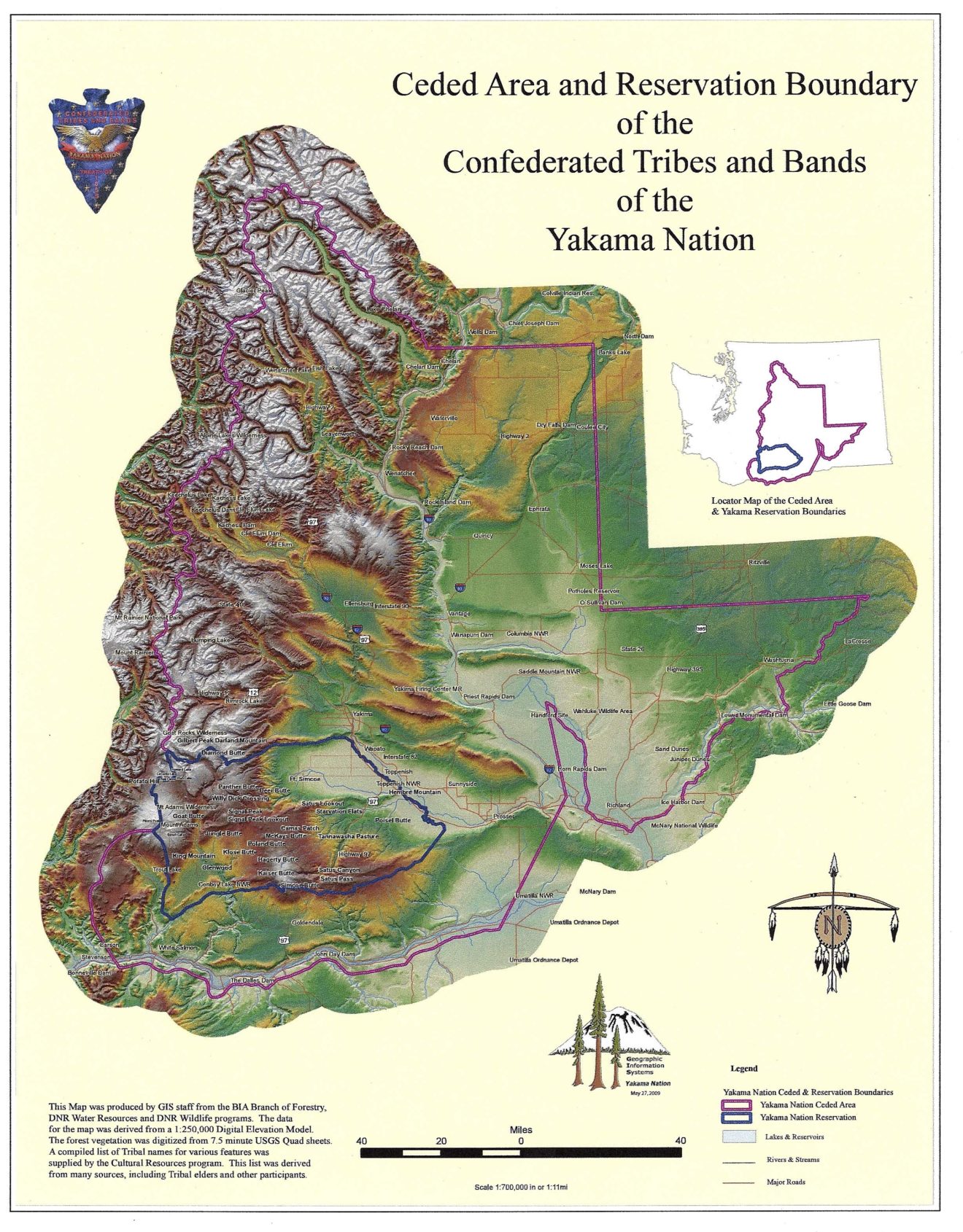
Map of yakama Nation Ceded Area & Reservation
Lands ceded to the federal government during the 1855 Treaty signing included over 12 million acres of land. But tribal elders have said that their distance of travel sometimes took them as far north as Canada and as far south as California.
The reserved portion of the tribal people’s original home land is where the tribes and bands were moved to. Tribal leaders reserved the right to fish, hunt and gather all of the tribe’s traditional foods on the reservation as well as the ceded area. Although the Treaty was signed on June 9, 1855 it did not become valid until ratified March 8, 1859 by the U.S. Senate and proclaimed law by the President on April 18, 1859. And just one month after the treaty was signed Governor Stevens through northwest newspapers declared all ceded lands open and available for white settlement.
The Yakima or Yakama Nation: Indian Reservation Treaty Details
Located in southwestern Washington State is the 1,130,000 acres reservation that is home to the Yakima or Yakama Indian Nation (AID, 39). That reservation was granted to the Yakama in a treaty signed in 1855 by Gov. Isaac Stevens of the Washington Territory and representatives of the Cayuse, Umatilla, Wallawalla, Nez Perce and Yakama tribes.
Although the treaty called for a period of two years to allow the various tribes to migrate to and resettle on their new reservations, Gov. Stevens declared Indian lands open for white settlers a mere twelve days after the treaty was signed (ENAT 253-254). A Yakama chief, Kamiakin called upon the tribes that had been duped to forcefully oppose this declaration, but not before they had built up their strength to oppose the military. Things moved too quickly and shortly thereafter a series of raids, counter raids and reciprocal atrocities began. This uprising became known as the Yakima War. The war continued until 1859, when the last phase, known as the Couer d’Alene War, ended. The Yakama accepted their reservation and still dwell there today. In addition to the Yakima, some Paiutes and a few members of other tribes reside on the Yakama Reservation.
The Yakama Nation, which is about 6,300 strong (AID, 39) has a flag (sample flag provided by Elmer’s Flag and Banner, Portland, OR) that shows the borders of the reservation in white against a sky blue background. Within the map is a depiction of Mount Adams, an impressive mountain that lies partly within the reservation. This mountain is sacred to the Yakama. Soaring above the mountain is an eagle depicted in full color. Not only is the eagle sacred, but it shares a lifestyle with many Yakama who earn their living fishing for salmon in the waters of the Columbia River and its tributaries.
Above the eagle is the “morning star” a symbol of guidance and leadership and arcing around Mount Adams are fourteen gold stars and fourteen eagle feathers honoring the bands of the Yakama nation. The feathers represent the fourteen chiefs that signed the treaty of 1855, while the fourteen stars represent the Confederated Tribes and Bands of the Yakama Indian Nations. The tribe’s name and the date of the treaty complete the design.
In 1955 members of the “Old Toppenish Long House” (Toppenish is a term the Yakama use to apply to themselves) adopted a flag to represent the Yakama people of the Yakama Reservation (“As Long As The River Flows”, Akwesosne Notes, III:4, May, 1971). The flag adopted at that time was similar to the present flag but did not include the Yakama Nation reservation map, nor did it have the writing on it. It is obvious that the flag adopted in 1955, the centennial of the treaty signing, was the basis for the current flag.
In the mid-1990s the Yakima nation renamed itself to “YAKAMA ” more closely reflecting the proper pronunciation in their native tongue. The only change made to the flag at the time of the name change was in the name. The flag above is correct except for the name Yakima which is now spelled Yakama.
Don Healy (Donh523@aol.com) 523 Centre St. Trenton, NJ 08611
Special thanks to Carol Craig, Fisheries Resource Management Public Information Manager • Confederate Tribes and Bands of the Yakama Nation for her contributions and writings of Yakama Nation history in the development of these web pages.